Hiking is a relative term, especially on Oahu. There’s such a diversity of trails — from the well-traversed path to the top of Diamond Head that people have done in flip-flops and high heels to the challenging six-mile ridge to the craggy summit of Olomana on the windward side — that there’s really a hike for everyone on the island.
There are trails just minutes from Waikiki and in just about every valley on Oahu. Some are paved; some are ungraded; and some are downright treacherous. But every one offers Instagram-worthy photos of the island, whether it’s lush valleys, rugged coastlines or offshore islands. Here are five trails that even the non-hiker can do — preferably in athletic shoes:
Makapuu Point Lighthouse Trail
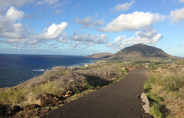
The entire three-mile trail is paved asphalt, all the way up the windswept cliffs above the easternmost point on the island. The summit overlooks the historic Makapuu Point Lighthouse built on a 600-foot sea cliff. The trailhead is located on Kalanianaole Highway past Hanauma Bay, about a 20-minute drive east from Forbes Travel Guide Four-Star The Kahala Hotel and Resort. There’s a parking lot — don’t keep valuables in your car, though, as this place is notorious for theft — and trash cans and scenic stops along the way. Midday, this can be a scorching-hot walk with hardly any shade along the coastal path. The best times to go are early mornings or at dusk. The panoramic views of the Pacific Ocean and the rugged Ka Iwi coastline are unparalleled. Between late December and early May, you may catch a glimpse of the endangered humpback whales that migrate to Hawaii’s warmer waters.
Toughen it: Just before you reach the summit, there’s a lookout with signage about migrating humpback whales. To the right is another trail that heads down to some tide pools at the ocean’s edge. This side trip can take up to half an hour.
Manoa Falls
Tucked away in the back of the verdant Manoa Valley, about five miles outside of Waikiki, is a short, easy hike to the 100-foot Manoa Falls. It’s less than a mile to get to the falls — you can’t swim here, by the way — and the trail crosses through eucalyptus trees and a grove of bamboo. The gradual uphill climb is one that anyone can do. It rains often in Manoa, so expect mud and mosquitos during your walk. There’s a parking lot at the trailhead that costs $5 (you also can find street parking in the residential neighborhood).
Toughen it: About 50 feet from the viewing area at the falls — and right near a mountain apple tree grove — is the start of another trail, Aihualama. It’s an eight-mile round-trip trek from Manoa Falls that cuts through a few gulches and climbs the side of the valley to the top of Tantalus. Few take this adjacent hike, with its steep ascents and numerous junctions. But the 360-degree view at the top of 2,014-foot Tantalus is breathtaking.
Aiea Loop Trail
If you’re looking for a longer hike that’s still pretty easy, get in your rental car and drive 12 miles west of Waikiki to the residential neighborhood of Aiea. At the top of Aiea Heights Drive is Keaiwa Heiau State Recreation Area, a 384-acre park with campgrounds, picnic spots and the trailhead for the 4.8-mile Aiea Loop Trail. This pleasant, mostly shady hike, which begins and ends at the park, is along the ridge on the west side of Halawa Valley and boasts views stretching from Pearl Harbor to Diamond Head. Along the trail, in a gully, see the wing section of a B-24 Army Air Corps bomber that crashed soon after taking off from Hickam Field in 1944.
Toughen it: On the path, you will reach an S-shaped curve at a junction with a trail that leads down the side ridge and through strawberry guava trees. (The Aiea Loop Trail continues straight.) This is the four-mile Kalauao Trail, which brings you to a popular waterfall with swimming holes. The hike back — it’s all uphill — is the challenge. There’s a reason why one particularly steep section is called Cardiac Hill.
Kaena Point Trail
On the westernmost point of Oahu is the site of one of the last dune ecosystems in the main Hawaiian Islands — and you can walk right through it. This remote and wild area, about 40 miles from Waikiki, is protected by a predator-proof fence that has helped restore the land and the natural habitat of native plants and animals. Starting from Kaena Point State Park in Waianae, the trail is mostly flat and follows the coast to the point, an ancient spot known as leina a kauhuna, or the “leaping place of souls.” This spot is home to nesting seabirds, monk seals and other native coastal species. Though it’s only about 2.5 miles to get to the point, the trail can be hot and windy, so bring appropriate footwear and sun protection.
Toughen it: For a longer hike, head all the way to the end of the trail in Mokuleia. That will add another two miles to your trek.
Kaiwa Ridge Trail
Not an official trail, the hike up to the pillbox bunkers above Lanikai is one of the more popular on the windward side of Oahu. It’s relatively easy — save for the initial ascent — and the views from the World War II bunkers of Lanikai and the Mokulua Islands offshore are unbeatable. The trailhead is located in the upscale residential neighborhood of Lanikai on Kaelepulu Drive. There’s a rope to help you up the first — and the hardest — section of the path. You’ll see the first bunker as soon as you get to the top. Admire the view from the two pillboxes here. Lots of people bring picnic lunches, too.
Toughen it: There’s a trail beyond the second pillbox, though it’s more dangerous and less traversed.
Photo Courtesy of Catherine Toth

